Tunnel Systems
Navigating the bridges and tunnels that connect Hampton Roads
One of the most remarkable features of our area is a network of underwater tunnels that connect various parts of the region. These engineering marvels offer practical transportation solutions while still allowing everything from international cargo ships to sailboats to travel in and out of our many ports and harbors.
Bridges & Tunnels Map
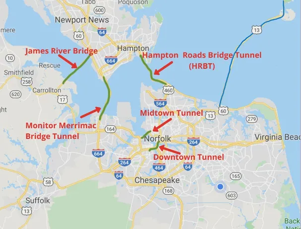
Downtown Tunnel
This tunnel goes through Downtown Norfolk, and connects West Chesapeake (called Western Branch), Suffolk, and Portsmouth to the city of Norfolk.
Midtown Tunnel
Connects West Chesapeake (called Western Branch), Suffolk, and Portsmouth to the city of Norfolk at a midtown location.
Hampton Roads Bridge Tunnel (HRBT)
This tunnel runs along I-64 and is the most common connection between the Hampton Roads Southside & the Peninsula.
James River Bridge
To avoid tunnel traffic altogether, this bridge connects western Hampton Roads to the Newport News area of the Peninsula.
Monitor Merrimac Memorial Bridge/Tunnel
The MMMBT is less traveled as it is less frequented by military commuters, but a convenient 2nd option for high traffic HRBT days.
Chesapeake Bay Bridge Tunnel
The Chesapeake Bay Bridge Tunnel connects the southside of Hampton Roads to the state's Eastern Shore via Route 13. This route takes you Northeast along the Coast towards Maryland, New Jersey, New York, etc. This is a more rural commute vs. going towards I-95 North, which routes you directly to Northern Virginia and Washington D.C.!
Tunnel Tips for New Residents
Avoid Rush Hour
Peak tunnel traffic is typically 7-9 AM and 4-6 PM on weekdays. Plan accordingly.
Check Traffic Apps
Use Waze or Google Maps to check real-time tunnel delays before departing.
Know Alternatives
If HRBT is backed up, the Monitor Merrimac or James River Bridge may be faster.